


We are officially in El Niño
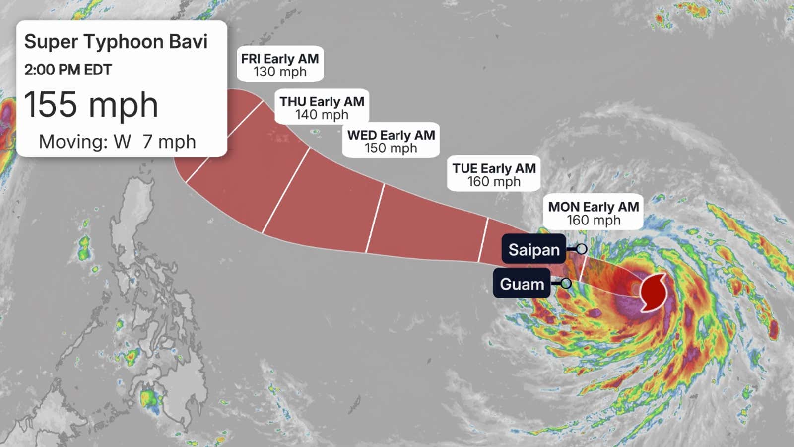
Super Typhoon Bavi is rapidly intensifying in the western Pacific Ocean and is forecast to strike the U.S. Mariana Islands, including Guam, as a super typhoon by Monday, with a potential for damaging winds, storm surge and flooding rain.
Where is it right now?
Bavi first became a tropical storm late Wednesday, and by early Friday it strengthened into a typhoon, which is what hurricanes are called in the western Pacific Ocean north of the equator, before reaching super typhoon strength later in the day.
It is centered under 400 miles east of Guam, moving west at 10 to 15 mph.
Where is it headed?
As the forecast map below shows, Typhoon Bavi is expected to continue its west-northwest track over the next several days.
On that track, the center of Bavi is expected to sweep through parts of the U.S. Mariana Islands chain, including Saipan, Tinian, Rota and Guam, sometime Monday, local time.
Guam is 14 hours ahead of U.S. Eastern Daylight Time and is about 1,700 miles southeast of Taiwan.
How strong could it become?
With plenty of deep, warm water, upper-level winds fanning outward from the system and lessening wind shear, Bavi rapidly intensified into a Category 5 equivalent typhoon Friday with 160 mph winds as a super typhoon.
Bavi is expected to be both a large and formidably strong typhoon when it arrives in the Marianas Monday.
(MORE: Why rapid intensification matters)
What we don’t yet know
While confidence is relatively high on the general nature of this forecast, there are several key details we don’t yet know, typical of forecasts for hurricanes and typhoons several days out:
- Where exactly the eyewall of Bavi will track, containing its most intense winds and highest storm surge.
- How fast Bavi will move, affecting how quickly conditions will deteriorate, how prolonged the storm will be and when conditions will improve.
- How large Bavi will become, affecting how widespread its impacts will be, even outside its eyewall.
Confidence is higher, however, that Bavi will produce bands of torrential rain not just during its closest approach, but also ahead of and for some time after the typhoon’s center has passed.
This will likely lead to dangerous flash flooding and landslides in hilly or mountainous terrain.
Prepare now
Regardless of these uncertainties, Bavi is a serious danger to the Mariana Islands, including Saipan, Tinian, Rota and Guam.
For now, we suggest having all preparations for Bavi completed by Saturday afternoon, as conditions could start to deteriorate by Sunday.
Bavi won’t be done after the Marianas
After Bavi moves past the Mariana Islands, it could then pose a threat to Japan’s Ryukyu Islands, Taiwan or eastern China late next week.
Interests in those areas should check back with us at weather.com for updates to this forecast in the week ahead.
All about Guam, Marianas typhoons
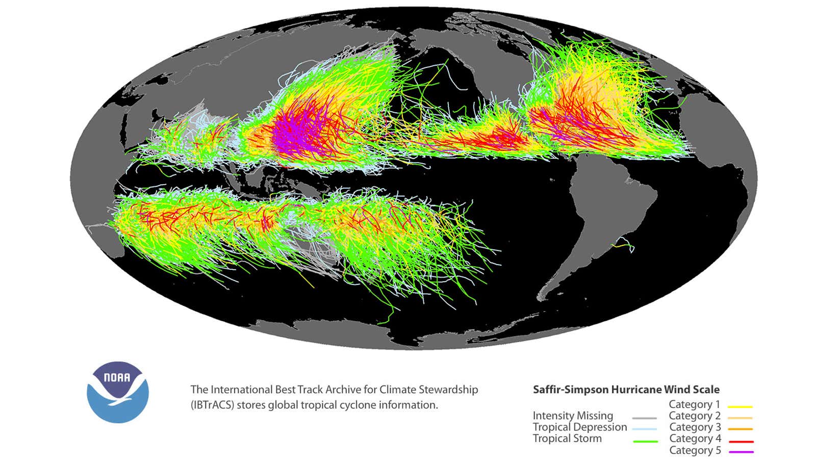
The western Pacific Ocean north of the equator is the planet’s most active zone for tropical cyclones.
In an average year, 25 to 26 tropical storms form in the northwestern Pacific Ocean, 16 of which become typhoons. That’s roughly a dozen more storms and nine more hurricanes (typhoons) as an average Atlantic hurricane season.
(NOAA)
Guam and the Northern Mariana Islands are typically affected by tropical storms or typhoons six to seven times each year.
While typhoons can occur in the western Pacific Basin any time of year, the season for the Marianas usually stretches from June through December.
Intense typhoons have struck the islands, recently.
Less than three months ago, Category 4 Super Typhoon Sinlaku clobbered the Northern Marianas and Guam with damaging winds, storm surge and rainfall flooding.
In May 2023, Category 4 Typhoon Mawar caused extensive damage to villages, pushed up to 14 feet of storm surge and dumped 1 to 2 feet of rain in Guam.
In late October 2018, Category 5 Super Typhoon Yutu slammed the islands of Saipan and Tinian with 175-mph winds, the strongest typhoon on record near those islands by wind speed.
Two people were killed and over 100 injured, numerous homes and buildings were damaged, including Saipan International Airport, and vegetation was stripped on parts of the islands.
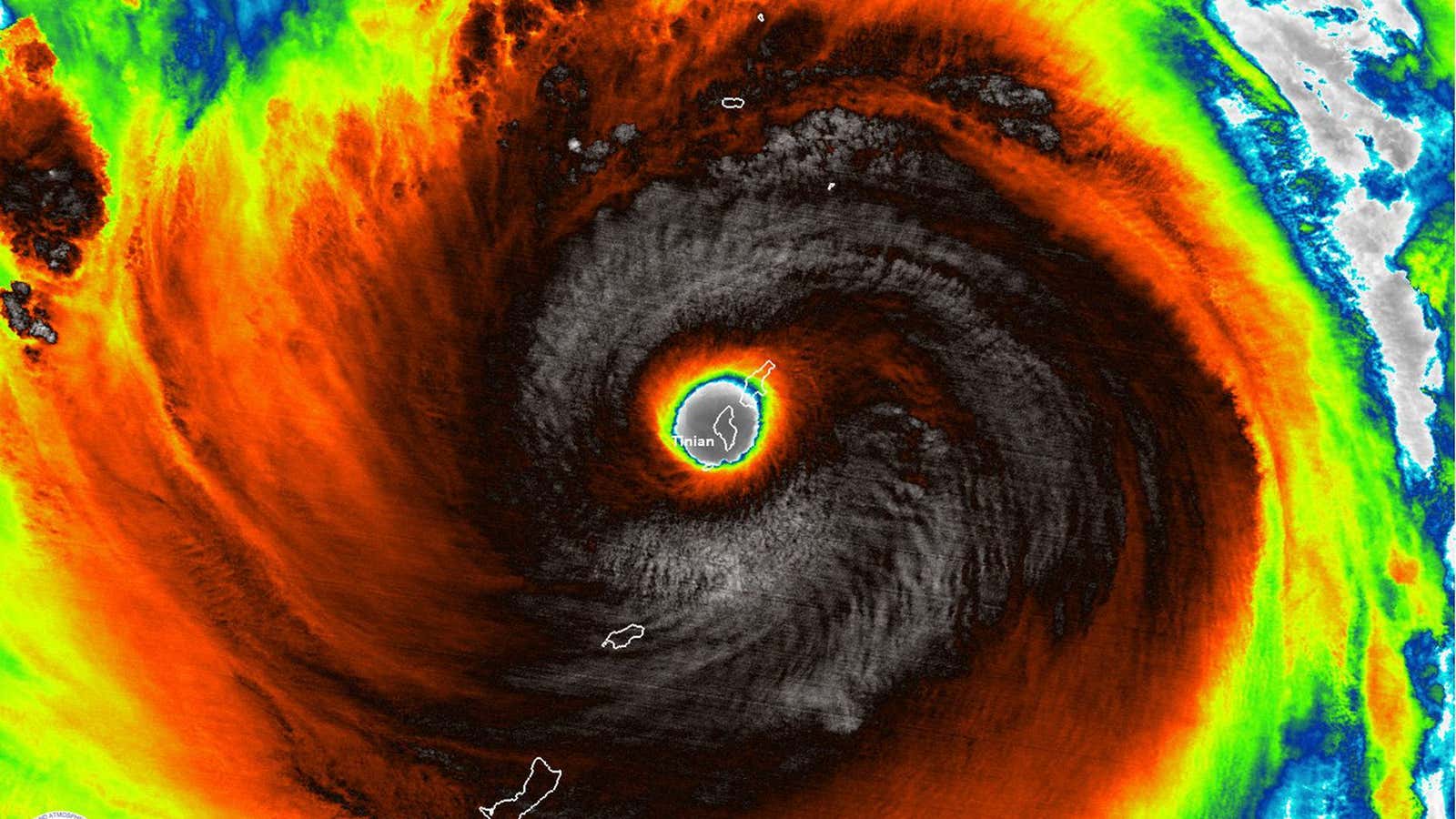
This infrared satellite image shows the island of Tinian completely engulfed by the eye of Super Typhoon Yutu on Oct. 24, 2018.
(UW-CIMSS)
Jonathan Erdman is a senior meteorologist at weather.com and has been covering national and international weather since 1996. Extreme and bizarre weather are his favorite topics. Reach out to him on Bluesky, X (formerly Twitter) and Facebook.

