


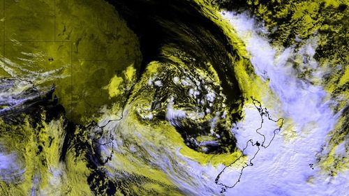
The weather system that brought cyclone-like winds and rain can be seen from space as it moves away from Australia.
As the system moves away from the east coast, it’s developing a colossal low-pressure complex covering most of the Tasman Sea.
As the system moves away, winds and rain are finally easing over the east coast.
However, the ocean will still be impacted by the moving system, with large and powerful tides bringing hazardous surf conditions to the entire coast.
Winds in Sydney, the Central Coast, Wollongong, and Newcastle will reach 20km/h this morning before easing midday.
NSW will see sunny weather today with clear skies with a high of 18 degrees.
The ACT will have similar conditions, with partly cloudy skies and light winds.
In Victoria, the day will be mostly sunny with some morning fog expected in the hills.
Temperatures will reach 15 degrees.
There’s a slight chance of showers in the northwest in the evening.
Winds will reach up to 30k/h.
Meanwhile, Queensland will see nearly perfect weather with sunny skies and slight winds, with only a small chance of rain.
Temperatures will reach 21 degrees.
In South Australia, temperatures will reach 19 degrees with partly cloudy conditions.
There’s a slight chance of showers in the hills and southern suburbs this morning.
Winds will reach up to 25km/h.
Tasmania will be mostly sunny with patches of frost and light winds.
Discover more from BrandedNepal | Shop Nepal’s Best Local & Global Brands
Subscribe to get the latest posts sent to your email.

