


HONOLULU (HawaiiNewsNow) – Major Hurricane Lowell is in the middle of its sharp turn toward the north on a track that should take it just west of Kauai and Niihau, which are now under both a Hurricane Warning and a Tropical Storm Warning.
A Hurricane Warning means that hurricane conditions are expected somewhere within the warning area and is typically issued 36 hours before the anticipated first occurrence of tropical-storm-force winds. These are conditions that make outside preparations difficult or dangerous. Preparations to protect lifeand property should be rushed to completion.
A tropical storm warning means tropical storm-force winds are expected somewhere within this area within the next 36 hours.
A Hurricane Warning has also been issued for the Papahanaumokuakea Marine National Monument.
At 11 p.m. Sunday, Lowell weakened slightly, with maximum sustained winds of 115 miles per hour. It remains a category 3 hurricane.
It was about 445 miles southwest of Lihue, or 480 miles southwest of Honolulu, and was moving to the north-northeast at 10 miles per hour.
Hurricane force winds extend outward up to 60 miles from the center, while tropical storm force winds extend up to 175 miles.
Lowell’s track expected to pass west of Niihau
Lowell is forecast to pass just west of Kauai County late Monday into early Tuesday. The current forecast track has been nudged a little bit eastward, increasing the probability of tropical storm force winds and hurricane force gusts for Niihau and Kauai.
Given the eastward shift in the track guidance and with the expectation that Lowell’s radii will also be larger on its eastern semicircle, the risk of hurricane conditions for Kauai and Niihau has increased.
South-southwesterly shear is forecast to increase to strong levels by tonight, which should induce a gradual weakening trend while Lowell is passing the Hawaiian Islands. However, Lowell is still forecast to be a hurricane when it makes it closest point of approach to the Hawaiian Islands on Monday night.
Lowell is forecast to turn toward the north-northwest and slow down by Tuesday night.
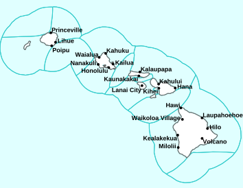
Local alerts issued for Hawaii
A Tropical Storm Warning is in effect for Kauai County, including the islands of Niihau and Kauai.
A Hurricane Warning is in effect for portions of the Papahanaumokuakea Marine National Monument, as well as Hawaiian offshore waters 40 to 250 nautical miles from coastlines.
A Hurricane Watch is in effect for Kauai County, including the islands of Niihau and Kauai.
A Flood Watch is in effect for all Hawaiian Islands through Tuesday afternoon. Heavy rain will be possible along the eastern flank of Lowell.
High Surf Warnings have been issued for the south-facing shores of all islands through 6 a.m. Tuesday.
- Kauai and Niihau: Surf of 7 to 10 feet through Monday morning, rapidly building to 20 to 30 feet Monday afternoon and evening.
- Oahu: Surf of 7 to 10 feet through Monday morning, rising rapidly to 12 to 20 feet Monday afternoon and evening.
- Maui County and Hawaii Island: Surf of 7 to 10 feet Monday morning, rising rapidly to 12 to 16 feet.
A High Surf Warning is also posted for the west shores of Hawaii Island. Surf of 6 to 8 feet is forecast through Monday morning, rapidly building Monday afternoon and evening to 12 to 16 feet.
A High Surf Advisory has also been issued for the east-facing shores of Oahu, Molokai, Maui and Hawaii Island for waves of 7 to 10 feet through Monday.
Potential impacts into the weekend
WIND: Hurricane conditions are possible and tropical storm conditions are expected in Kauai County by Monday afternoon or evening. Hurricane conditions are possible in in the Papahanaumokuakea Marine National Monument between Nihoa and French Frigate Shoals Monday night, with tropical storm conditions beginning Monday afternoon. Wind speeds atop and on the windward and leeward sides of hills and mountains are often up to 30 percent stronger than the near-surface winds, and in some elevated locations could be even greater.
RAIN: Hurricane Lowell is expected to produce rainfall totals of 6 to 10 inches for Kauai, with maximum totals of 14 inches possible. For Hawaii Island, 4 to 8 inches of rain is expected with isolated totals of 12 inches possible. For Maui, 2 to 4 inches of rain is expected, with isolated maximum totals of 8 inches possible. Across the remaining islands, rainfall of 2 to 4 inches is possible. This rainfall may produce significant flash flooding and mudslides, especially across Kauai County and portions of Hawaii Island.

TORNADOES: Several tornadoes WILL possible near Kauai and Niihau Monday afternoon through Monday night. A few tornadoes are also possible across the rest of the Hawaiian Islands.
STORM SURGE: The combination of storm surge and tide will cause normally dry areas near the coast to be flooded by rising waters moving inland from the shoreline. The water could reach the following heights above ground somewhere in the indicated areas if the peak surge occurs at the time of high tide:
- Kauai County: 1-3 ft.
- Oahu: Up to 1 ft.
The deepest water will occur along the immediate coast near and to the right of the center, where the surge will be accompanied by large and destructive waves. Surge-related flooding depends on the relative timing of the surge and the tidal cycle, and can vary greatly over short distances.
SURF: Swells from Lowell are likely to cause life-threatening surf and rip current conditions during the next several days across many of the Hawaiian islands.

Watch our Q&A on Hurricane Lowell here:
Karina now a post-tropical cyclone
Meanwhile, Karina is rapidly weakening and is now a post-tropical cyclone northeast of Hawaii. Karina’s remnants are expect to dissipate in the next day or two.
This continues to be an active hurricane season. Have a hurricane plan and supply kit in place for this weekend. Now is the time to make a plan for a worst-case scenario so you can take action if and when needed.
Your First Alert Weather Team will continue to monitor both systems closely over the next several days.
Data provided by the National Hurricane Center.
Related posts
- Get the latest First Alert Forecast
- How to build a hurricane kit: Tips to help your family prepare for emergencies
Download the HNN Weather app from the Apple App Store or Google Play for the latest updates from your First Alert Weather Team: chief meteorologist Jennifer Robbins and weather anchors Guy Hagi, Dan Cooke, Ben Gutierrez, and Billy V.
Copyright 2026 Hawaii News Now. All rights reserved.
Discover more from BrandedNepal | Shop Nepal’s Best Local & Global Brands
Subscribe to get the latest posts sent to your email.

